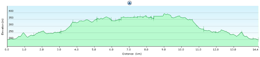
hello, is the trail 14 km one tour or is this for start and back/return? are the last part over a mountain …i think…is this very difficult…maybe for a child 5 years? thanx a lot bye. luana
Hello, those 14 km is there and back to the starting point (=> 7 km one way). Overall it’s not a difficult track, but it depends greatly on season of the year. Asi I say in the article (http://ok1cld.info/sardinia-2010-gola-su-gorroppu-20th-july/), when we were there (on 20th July), the trip was very exhausting due to high temperatures. I guess for example in spring or autumn it’s not difficult at all. Ondra
2 Comments
hello, is the trail 14 km one tour or is this for start and back/return? are the last part over a mountain …i think…is this very difficult…maybe for a child 5 years? thanx a lot bye. luana
Hello, those 14 km is there and back to the starting point (=> 7 km one way). Overall it’s not a difficult track, but it depends greatly on season of the year. Asi I say in the article (http://ok1cld.info/sardinia-2010-gola-su-gorroppu-20th-july/), when we were there (on 20th July), the trip was very exhausting due to high temperatures. I guess for example in spring or autumn it’s not difficult at all. Ondra